Comprehensive Golf Course Management Solutions

At DroneScape, we offer a range of advanced drone services designed specifically for golf courses. Our precision drone imagery and data analytics provide course managers with detailed insights that were previously impossible to obtain.

Managing a golf course requires an eye for detail and a proactive approach to landscape maintenance. Our specialized golf course surveys give you a comprehensive view of your greens, fairways, and roughs, helping you identify issues before they affect playability.

From detailed green book mapping to comprehensive turf health monitoring, our services help you maintain optimal course conditions while reducing maintenance costs and improving resource allocation.

Golf Course Drone Survey
Green Book Mapping

Green Book Mapping

Our green book mapping service provides detailed insights into the contours and undulations of each green on your course. Using advanced drone technology and photogrammetry, we create precise 3D models that help:

  • Players improve their putting strategy
  • Groundskeepers maintain optimal green conditions
  • Course managers plan renovations and improvements

Each green book includes comprehensive slope analysis, contour maps, and detailed measurements, giving you unprecedented insights into your course's most critical areas.

Learn More

Turf Health Monitoring

Our multispectral imaging technology allows us to assess the health of your turf with incredible precision. By capturing data beyond what's visible to the human eye, we can help you:

  • Identify dry patches and irrigation issues
  • Detect early signs of disease or pest infestation
  • Monitor nutrient levels across your course
  • Track turf health over time with historical comparisons

This proactive approach to turf management helps you address issues before they become visible problems, saving time and resources while maintaining exceptional playing conditions.

Learn More
Turf Health Monitoring
Surface Analysis

Detailed Surface Analysis

Our comprehensive surface analysis provides critical measurements and insights about your course's terrain, including:

  • Surface area calculations for precise maintenance planning
  • Volume measurements for material requirements
  • Perimeter and elevation data for boundary management
  • Slope analysis for drainage and irrigation planning

This detailed data helps you optimize resource allocation, plan renovations, and address drainage issues with precision and confidence.

Learn More

Precision Maintenance

Our drone surveys enable a targeted approach to course maintenance, helping you:

  • Identify specific areas requiring attention
  • Reduce unnecessary maintenance traffic on the course
  • Optimize resource allocation for fertilizers and treatments
  • Plan efficient maintenance schedules based on actual needs

This precision approach not only improves course conditions but also reduces maintenance costs and minimizes disruption to players.

Learn More
Precision Maintenance

Our Process

1

Initial Consultation

We begin with a detailed discussion of your course's specific needs and challenges to tailor our services accordingly.

2

Drone Flight & Data Collection

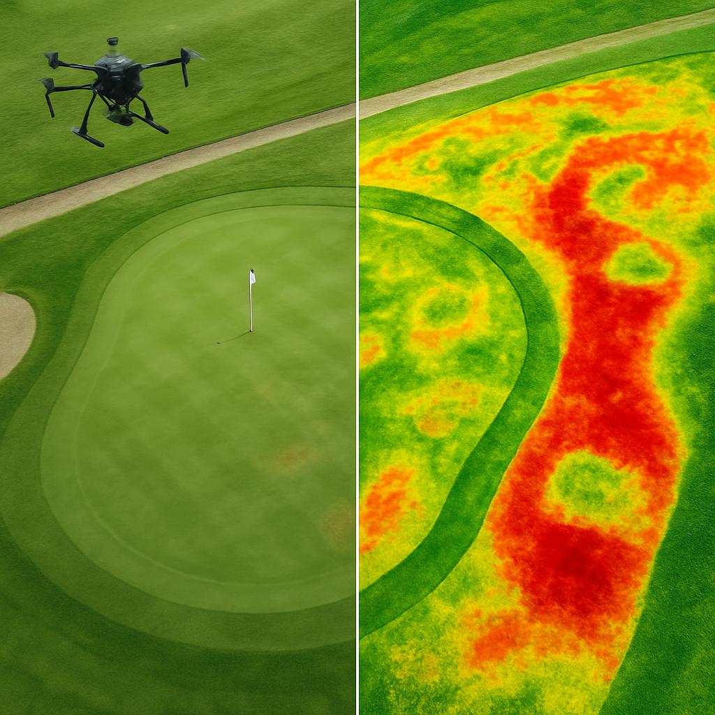
Our expert team conducts comprehensive drone flights over your course, capturing multispectral imagery and detailed terrain data.

3

Data Processing & Analysis

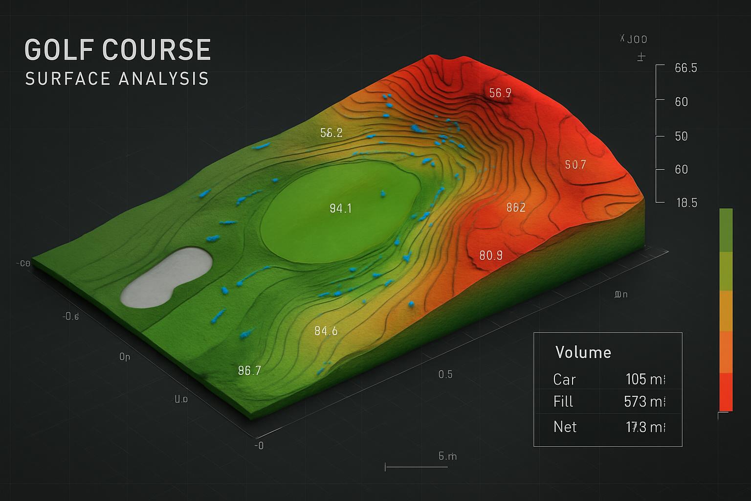
We process the collected data using advanced software to create detailed maps, 3D models, and analytical reports.

4

Insights & Recommendations

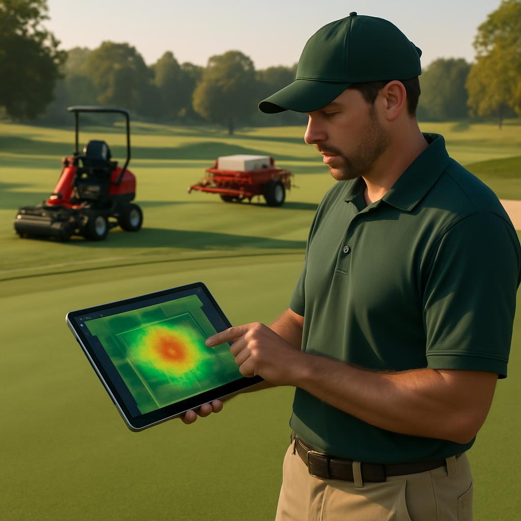
Our team provides you with actionable insights and specific recommendations based on the analyzed data.

5

Implementation Support

We offer ongoing support to help you implement our recommendations and maximize the benefits of our services.

Success Story

Case Study - Pretoria Golf Club

Pretoria Golf Club Transformation

Pretoria Golf Club was facing challenges with inconsistent green conditions and high maintenance costs. After implementing our comprehensive drone services:

  • They identified and resolved irrigation issues that were affecting 30% of their greens
  • Reduced water usage by 25% through targeted irrigation
  • Decreased fertilizer costs by 20% through precision application
  • Improved player satisfaction scores by 40%

"DroneScape's services have transformed how we manage our golf course. The detailed insights have helped us optimize our maintenance schedule and significantly improve the quality of our greens." - John Smith, Golf Course Manager

Our Packages

Basic Assessment

Contact for Pricing
  • Single Drone Flight
  • Basic Orthomosaic Images
  • Simple Course Overview
  • Basic Turf Health Assessment
  • Digital Report
  • Green Book Mapping
  • Historical Data Comparison
  • Online Access Portal

Premium Monitoring

Contact for Pricing
  • Quarterly Drone Flights
  • Ultra-High-Resolution Imaging
  • Complete Course Analysis
  • Advanced Turf Health Monitoring
  • Premium Green Book Mapping
  • Interactive 3D Course Models
  • Historical Data Comparison
  • Premium Online Access Portal

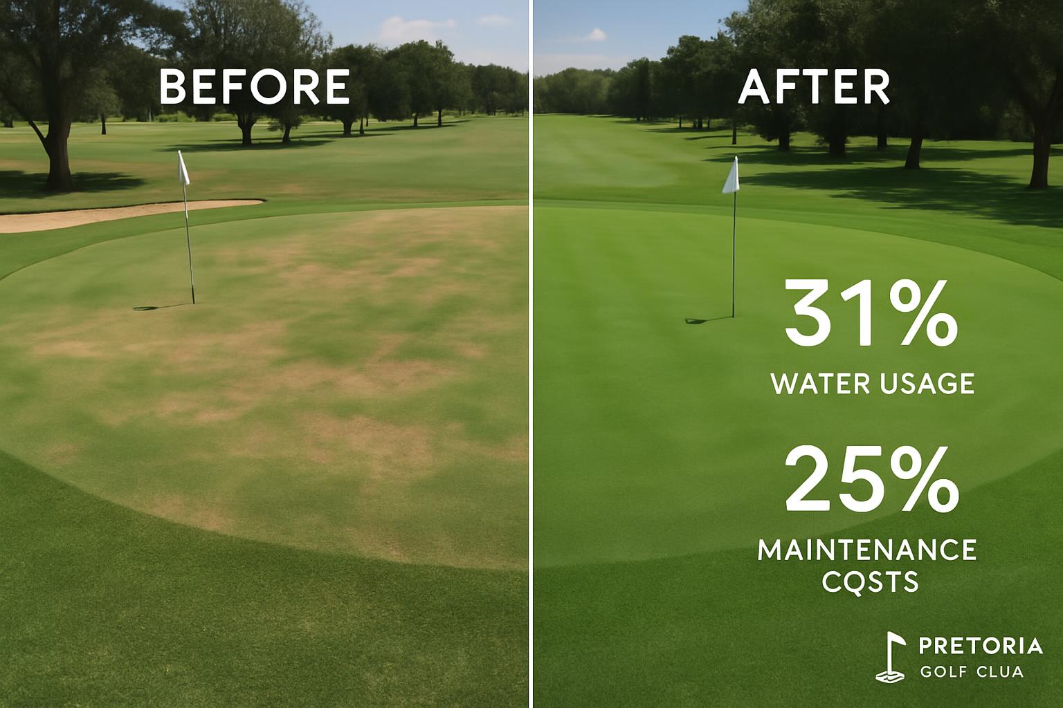
All packages include data processing, analysis, and consultation. Custom packages are available to meet your specific needs.

Frequently Asked Questions

How often should we conduct drone surveys of our golf course?

The optimal frequency depends on your specific needs and challenges. For most courses, we recommend quarterly surveys to track seasonal changes and address issues proactively. However, courses with specific challenges may benefit from more frequent assessments, while others might only need bi-annual surveys.

How long does it take to complete a drone survey of an 18-hole course?

A standard drone survey of an 18-hole course typically takes 1-2 days for data collection, depending on weather conditions and the specific services requested. Data processing and analysis usually require an additional 3-5 days before we deliver the final reports and insights.

Will drone flights disrupt play on our course?

We schedule our drone flights to minimize disruption to your operations. This often means early morning flights before play begins or working around your course's schedule. Our experienced pilots operate efficiently and safely, ensuring minimal impact on your players' experience.

How accurate are your green book maps?

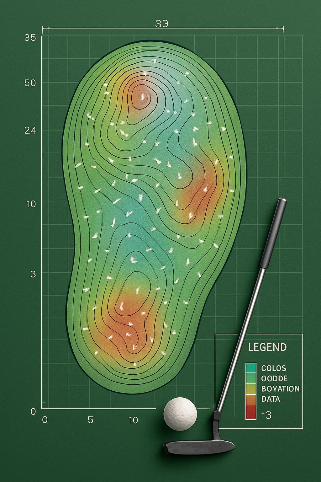
Our green book maps are highly accurate, with contour measurements precise to within 5cm. We use advanced photogrammetry techniques and ground control points to ensure the highest level of accuracy in our 3D models and slope analyses.

How do we access the data and reports after the survey?

All data, maps, and reports are accessible through our secure online portal. You'll receive login credentials to access your course's information from any device. The portal includes interactive features that allow you to explore 3D models, compare historical data, and download reports as needed.

Ready to Transform Your Golf Course Management?

Contact us today to schedule a consultation and discover how our drone services can help you maintain a superior golf course while reducing costs.

Get in Touch